Being Neighbourly discovers a winsome mix of history, recreational opportunities and academia in Sha Tin.
Author/
Being Neighbourly
Share
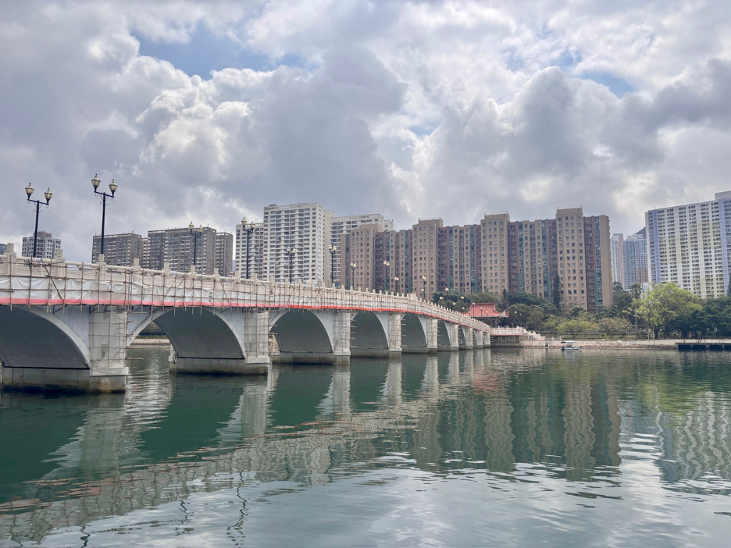
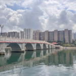
Shing Mun River, Sha Tin. All photos courtesy of Tasfeeha Tajudeen.
Sha Tin is the most populated district in Hong Kong, where inhabitants were settled as early as four thousand years ago. Once named Lee Yuen, the establishment of the Sha Tin station of the Kowloon-Canton Railway (British Section) in 1910 led ‘Sha Tin’ to become the more common name for the area.
Ask your neighbours about the district and chances are you’ll hear about some of the highlights: the race course, the 10,000 Buddha Temple or Snoopy World. Maybe even about the presence of IKEA.
Less well known, is that Sha Tin is famous for certain local variants of Cantonese food such as Shan Sui Tofu ‘mountain-water bean curd’, BBQ pigeon and chicken congee. The cooked food stalls in Wo Che Estate and Fo Tan (see below) are hotspots for those seeking a good plate.
Aside from the Sha Tin equestrian racecourse, which has a capacity of 85,000; Penfold Park and Sha Tin Park are other recreational highlights there.
The district is also the location of the Chinese University of Hong Kong (CUHK), accessible via the MTR East Rail line at University station; as well as a host of other places of tertiary education: Hang Seng University of Hong Kong; Hong Kong Baptist University (Shek Mun Campus); Hong Kong Sports Institute and Institute of Vocational Education.
There are four hospitals in Sha Tin.
Land Area 69.46 km2
Population* 692,806
*2021 figures
Biggest Neighbourhood Sha Tin
Sha Tin
Sha Tin, also spelt Shatin, is a neighbourhood along Shing Mun River, as well as the name of the district. Sha Tin translates to ‘sand’ and ‘field’. The name referred to the sandy plains, agricultural land and river deposits of the area.
Tai Wai
Tai Wai is located between Sha Tin and the Lion Rock and is an important transport node in Hong Kong, with three rapid transit stations, one of which is an interchange station serving two lines, five bus termini and several trunk roads and tunnels connecting it to other parts of the New Territories. Tai Wai Village, built in 1574 during the Ming Dynasty, is the oldest and largest walled village in Sha Tin District.
Ma On Shan
Ma On Shan is a new town along the eastern coast of Tolo Harbour. The neighbourhood takes its name from the twin peaks of Ma On Shan, which are partly located within the town.
The three treasures of Ma On Shan historically included iron ore, primarily exported to Japan from the 1950s to the 1970s; Azaleas, particularly the species Rhododendron Hongkongense, which bloom in April and are celebrated during the annual Ma On Shan Azalea Festival, which promotes six locally native species; and the Indian muntjac, also known as Barking deer, known for its shy nature and distinct barking sound during mating. Public housing estate development began in the mid-1980s, The Ma On Shan line of the MTR, which opened in 2004, was later merged into the Tuen Ma Line.
Fo Tan
Fo Tan was developed as a light industrial area, but since 2001, due to most industrial businesses closing and relocating to Mainland China, over 70 units in the utilitarian industrial blocks of Fo Tan have reopened as artists’ studios, creating a vibrant local arts scene.
Fo Tan was selected for artist spaces due to its high ceilings and central location in the New Territories and each January, the Fotanian Open Studio Programme invites the public to explore these usually private working studios.
There are residential areas to the east, alongside the MTR line, and in the foothills to the west.
How to get there:
MTR(Subway):Take the East Rail Line directly to Sha Tin Station (or Tai Wai / Fo Tan depending on your exact destination).You can also connect via the Tuen Ma Line.
Bus:Numerous KMB routes connect urban areas directly to Sha Tin Central Bus Terminus or New Town Plaza.
Taxi:Both Urban (red) and New Territories (green) taxis can serve Sha Tin.Red taxis can bring you in from anywhere in Hong Kong (Island, Kowloon, NT), while green taxis operate within the New Territories.
Siu Lek Yuen
Siu Lek Yuen is located to the east of Yuen Chau Kok. The area is surrounded on three sides by the Ma On Shan Country Park. Siu Lek Yuen was originally a ford of Tide Cove (a shallow part of a river or bay that was easy to cross by walking or driving). Tide Cove was the original narrow sea bay that stretched into the Sha Tin valley before urban development.
Today, Siu Lek Yuen is a residential area. Hang Seng University of Hong Kong is located at the south-west of Siu Lek Yuen.
Ma Liu Shui
Ma Liu Shui faces Tide Cove (Sha Tin Hoi) and Tolo Harbour and is the location of the Chinese University of Hong Kong and the Hong Kong Science Park.Originally barren land inhabited by Hakkas until 1956, when Chung Chi College was granted 10 acres to build its campus, a KCR station, also named Ma Liu Shui station, was opened there before being renamed University station.
Between 1969 and 1973, academic buildings for CUHK, New Asia College, and United College moved next to Chung Chi College. In the 1980s, University station became a major transit point due to the redevelopment of the nearby new town in Ma On Shan. The opening of the Ma On Shan line in 2004 facilitated movement.
Another noteworthy landmark is the ferry dock in Ma Liu Shui, connecting the public to Tung Ping Chau (Hong Kong’s easternmost outlying island, located in Mirs Bay and designated as part of the Hong Kong UNESCO Global Geopark) and acting as a gathering spot for weekend sightseeing trips around the New Territories.
How to get there (Ma Liu Shui):
MTR (Subway):Take the East Rail Line to University Station. From Exit B, it is a direct 10- to 15-minute walk through the pedestrian tunnel to reach the Ma Liu Shui Public Pier, or a short connection into the Chinese University of Hong Kong (CUHK) and nearby Science Park areas.
Ferry: Ma Liu Shui is a major departure point rather than a destination for urban ferries. Kaito ferries operate regularly from Ma Liu Shui Public Pier out to outlying destinations in the Northeast New Territories, including Tap Mun (Grass Island), Tung Ping Chau, and Lai Chi Wo.
Bus:Numerous KMB and Green Minibus routes pass through Ma Liu Shui, connecting from University Station Bus Terminus or along Science Park Road.
Taxi: Both Urban (red) and New Territories (green) taxis serve Ma Liu Shui.
Stay posted for our Sha Tin insider guides coming soon.
Share
About the Author
Being Neighbourly
For over 20 years, the people behind BN have been creating content on the best things in life: food, travel and inspirational people.
Ditch The Cafes
Experience a 5-star flexible workspace just 4 minutes from the MTR